Day 46: Meet the JMT
June 15, 2015
Crabtree Meadow Ranger Station (1.3 on Alternate) to Tentsite before Bullfrog Lake Trail (788.6)
1 Alternate mile (Mt. Whitney Summit), 21.7 PCT/JMT miles
818.3 miles total
Today’s Elevation Gain/Loss: + 4,311 ft, – 4,928 ft

I truly did not believe that anything would top yesterday’s Mt. Whitney summit, at least not anytime soon. And then today came along. With its early start, climb up Forester Pass, dip in a glacial lake, and descent through Kings Canyon National Forest, today did the unthinkable…it became our new favorite day.
 Yesterday’s relaxing afternoon meant that today we’d need to hammer out a full 22 miles, including Forester Pass (the highest point on the PCT at 13,098 feet). The one thing that makes hikers push through the Sierras and put in their mileage day after day, rather than sit by the wild rivers and crystal blue lakes all afternoon long, is our meticulous rationing of food. If you carry 6 days of food with you into the Sierras, and then you don’t complete your miles before your food runs out, you’re going to be hungry. Speaking of being hungry, have I mentioned that Pickles and I are starving? Okay, maybe not literally starving, but we totally underestimated how hungry we’d be in the Sierras and seriously under-packed on food for this section. We’ve done a good job of rationing it out and we’ll make it to tomorrow morning’s Nero in Lone Pine, but it hasn’t really been comfortable. We must just be burning more calories with the cooler weather and high altitude, but we are definitely going to need to just about double our rations for this next section. This is not going to make for light packs. But anyway, back to this incredible, if not calorie-deprived day in the Sierras.

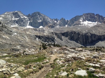
So in order to make sure we’d get in our mileage Pickles and I set our alarm for 4am and hiked out of the Ranger Station by 5:15…our earliest start time yet. The morning miles flew by and we felt wonderful by the time we crossed a huge river and faced the 5-mile climb up Forester. Staring at the peaks before us, we couldn’t fathom a way through, and when we finally pieced together our trail and located the pass, we were in awe. The trail was literally cut into the rock wall and for the last mile, the drop-off on one side became steeper and steeper. The pass itself was a marvel. It offered 360 degree views of the Sierras, with glacial lakes and pine-drenched valleys dotting the surface. It was breathtaking. We had lunch at the top – it was high noon when we arrived and there was neither a hint of wind nor a cloud in the sky – and then we began our hike down into the Kings Canyon forest, a thriving and colorful ecosystem full of trees, streams, and our newest spectacle – JMT hikers.
The JMT, or the John Muir Trail, is a scenic trail that runs 200 or so miles through the Sierras from Yosemite Valley to the top of Mount Whitney. It is a super popular hike, for excellent reason, and as it turns out, it shares the same trail as the PCT for all but about 30 of its miles. It is easy to spot a JMT hiker out here because they are usually hiking Southbound, and their backpacks are gigantic. We have to give them credit though because the hikers we’ve seen have made it this far, to their final pass, carrying way more weight than Pickles or I could, or would want, to manage for even a day.

As we jogged down the north side of Forester Pass, JMT hikers huffing and puffing their way up, we noticed one particular glacial lake that was right on trail and looked especially inviting. It was still the middle of the day and nice and warm out so Pickles and I came to the obvious conclusion that we needed to jump in. We dropped our packs, undressed down to our undies, and each took a turn diving from a rock into the coldest water I’ve ever been submerged in. Most of the lake was literally covered in a sheet of ice. It was freezing, thrilling, incredibly refreshing, and the perfect way to celebrate our victory over Forester Pass.


The rest of the afternoon was spent gallivanting through a picture-perfect forest, staring wide-eyed at the massive granite peaks on all sides. Our feet didn’t hurt at all today – actually nothing hurt – and we finished the planned 22 miles by 5pm. We realized as the day went by how nice the extra-early start had been, since we didn’t feel at all rushed and instead took breaks or sat and stared at the views more often than we usually allowed.

Our campsite tonight is surrounded by pines, right along the edge of yet another stream. The skies are still clear and we’ve left the rain fly off our tent for now so we can watch the sun set while we sit and eat dinner protected from the newest addition to our hiking life – swarms of mosquitos. They really aren’t bad yet, but it is nice to know that they can’t get us in here, and we can listen to the creek, watch the sun set, and stay warm and protected all at the same time. Tomorrow morning we’ll hike 7.7 miles off the PCT over Kearsage Pass to a campground where Mama Bear is camped out and waiting for us. We’ll take a Nero in Lone Pine, eat a lot of food, and then load up our packs to come back out for another wonderful week of hiking.


I love reading all about your adventure! Hope to see you when your in Tahoe!
Hey Danielle! Awesome…thanks for checking out the blog! We’ll be in town for the 4th so will definitely hope to see you guys 🙂